
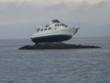
GSL Slip Renters. Although we will try, we may not be able to issue weather forecasts for the Great Salt Lake on Wednesday and Thursday. This may be the same case next Wednesday and Thursday also. So, to cover our basis the best I can I am going to provide some weather warnings now: Hurricane Force.jpg HURRICANE FORCE WARNING GREAT SALT LAKE MARINA AREA for Wednesday through 8pm Winds 30 to 50mph with gusts over 75mph are possible Storm Warning.JPG GALE FORCE WARNING GREAT SALT LAKE NORTH for Wednesday through 8pm Sustained winds on the lake could exceed 50mph Boat Aground.jpg NEGATIVE STORM SURGE WARNING Lake levels at the Great Salt Lake Marina could drop as much as a foot causing very shallow conditions at the mouth of the marina. WEDNESDAY FORECAST Mostly cloudy, with a high near 49. Some thunder is possible at times. Windy, with south winds 20 to 50mph and some gusts possibly exceeding 75mph. Rain and snow likely at night, becoming all snow after 11pm. Some thunder is also possible. Cloudy, with a low around 30. Windy, with northwest wind 30 to 40mph behind the front. Chance of precipitation is 70% THURSDAY FORECAST A chance of snow showers (more likely a Wasatch Front occurrence rather than a Great Salt Lake occurrence). Mostly cloudy, with a high near 38. Little to no snow accumulation. A chance of snow Thursday night, with a low of 23. NOAA WARNING THE NATIONAL WEATHER SERVICE IN SALT LAKE CITY HAS ISSUED A HIGH WIND WATCH...WHICH IS IN EFFECT FROM WEDNESDAY AFTERNOON THROUGH WEDNESDAY EVENING. * AFFECTED AREA: THE SALT LAKE AND TOOELE VALLEYS...GREAT SALT LAKE DESERT AND MOUNTAINS...WEST CENTRAL AND SOUTHWEST UTAH. THIS INCLUDES INTERSTATE 80...SALT LAKE CITY...TOOELE...DELTA... FILLMORE...BEAVER...CEDAR CITY...MILFORD. * WINDS: SOUTH 30 TO 40 MPH WITH GUSTS POTENTIALLY EXCEEDING 60 MPH. * TIMING: DEVELOPING WEDNESDAY AFTERNOON AND LASTING THROUGH THE EVENING. * IMPACTS: MOTORISTS DRIVING INTERSTATE 80 AND ROUTES 50...21...AND 56 WILL SEE STRONG CROSS WINDS MAKING FOR DIFFICULT DRIVING CONDITIONS ESPECIALLY FOR HIGH PROFILE VEHICLES. BLOWING DUST MAY CAUSE REDUCED VISIBILITIES. WIND SENSITIVE OPERATIONS WILL BE AFFECTED. PRECAUTIONARY/PREPAREDNESS ACTIONS... A HIGH WIND WATCH MEANS THERE IS THE POTENTIAL FOR A HAZARDOUS HIGH WIND EVENT. SUSTAINED WINDS OF AT LEAST 40 MPH OR GUSTS OF 58 MPH OR STRONGER MAY OCCUR. CONTINUE TO MONITOR THE LATEST FORECASTS. &&ROGOWSKI FOR MORE INFORMATION FROM NOAA/S NATIONAL WEATHER SERVICE VISIT... HTTP://WEATHER.GOV/SALTLAKECITY (ALL LOWER CASE) Dave Shearer Harbormaster Great Salt Lake State Marina 801-209-9142
participants (1)
-
 Dave Shearer